Harney Point Massacre
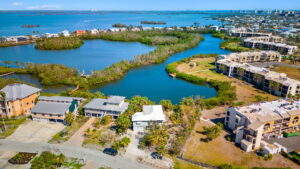
Between 1816 and 1858 the United States Army faced off with the Seminole Indians in one of the longest and costliest Indian War ever fought in the United States. Known as the “Harney Point Massacre,” this bloody battle took place where the Cape Coral Bridge is today.
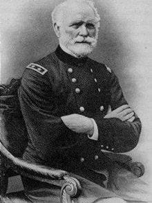
Colonel William Harney commanded a trading post on the north side of the river. On July 22, 1839, as many as 200 Miccosukee, Creek, and Seminole Indians attacked Harney’s outpost because they thought the soldiers were there to capture the Indians and ship them to Indian Territory in Oklahoma.
The Indians attacked in the early morning hours as the troops slept. Most of the soldiers were killed in their beds before they had a chance to get to their weapons. Eighteen troops and four civilians were killed, and nine soldiers, including Harney, managed to escape by jumping into the river and swimming to their boats.
After the massacre, the army post was abandoned, and, 11 years later, a new army post was established a few miles north of the original post. The new post was named “Fort Myers.”

Early Homesteaders
Almost forty years later, in 1872, the area known as “Harney’s Point” was opened for homesteading. John Powell was one of the first settlers in the area to homestead on a creek near Bayshore Road. A few other hardy souls followed Powell, but by the time Lee County was created in 1887, the majority of the land in what is now the Cape was owned by the Atlantic Gulf Coast Canal and Okeechobee Land Company. The few settlers who had attempted to live on the “other side of the river” found it hard to make a living and moved back to Fort Myers.

In the early 1920s, a few lumbering companies were operating in the area. By 1924, there was a sawmill that operated until 1944 when the area was timbered out. In 1929, for example, approximately 120,000 board feet of pine was cut down every day. During the 1940s, the Matlacha Cattle Company owned 25,000 acres from Pine Island Road to the river.
It is hard to imagine what the Cape was like back in the day. Instead of roads and canals, the land was nothing more than hammocks consisting of sweet and red bay, black and sweet gum, palmettos, magnolia, huckleberry and mangroves as well as live oaks, red cedar, slash pine, strangler figs, hickories, and myrtle.
From 1930 to 1950, the Cape was consisted of a few homesites, gladiolus and vegetable farms, drainage canals, a few citrus trees, and a couple of windmills.
The area was remote, isolated, and inaccessible. Hunters were frequently found shooting quail, turkey, deer, and wild hogs. Squatters lived in shacks along the riverbank where they caught snook, mackerel, red fish and tarpon.
This all changed in 1958 when Leonard Rosen took an airplane ride over the Cape and realized its potential as a vibrant community.
More on the development of the Cape in future posts.